PLATFORM/LUCARELLI Fosco The Origins of The Plan: Forma Urbis Romae (2018)
PLATFORM/LUCARELLI Fosco The Origins of The Plan: Forma Urbis Romae (2018)
200109
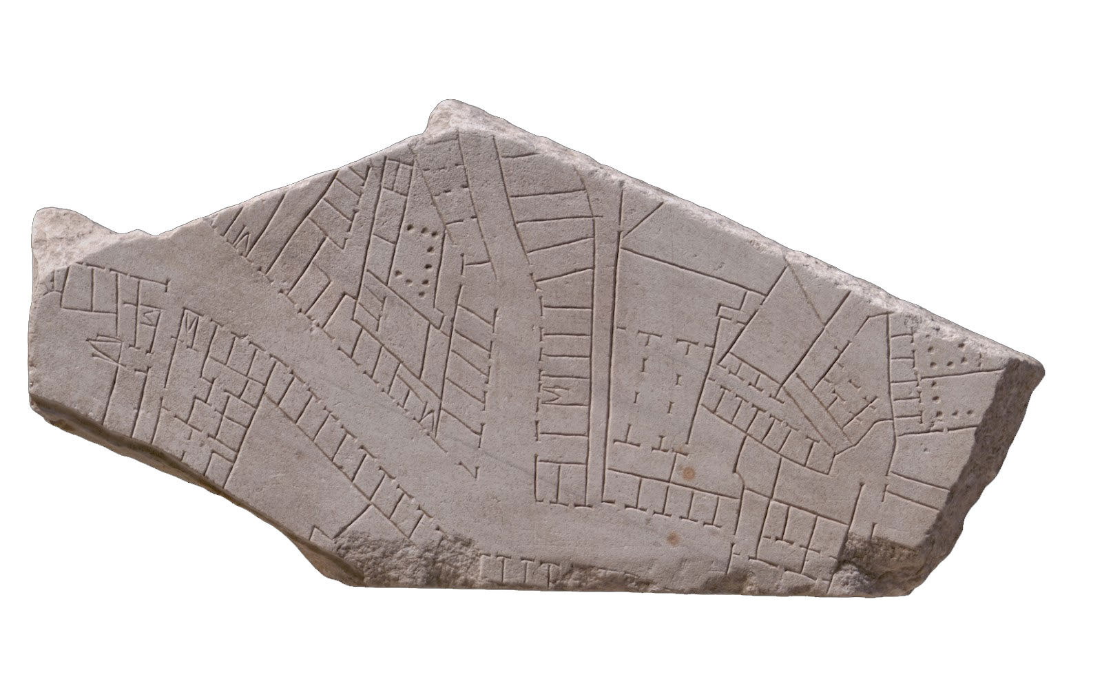
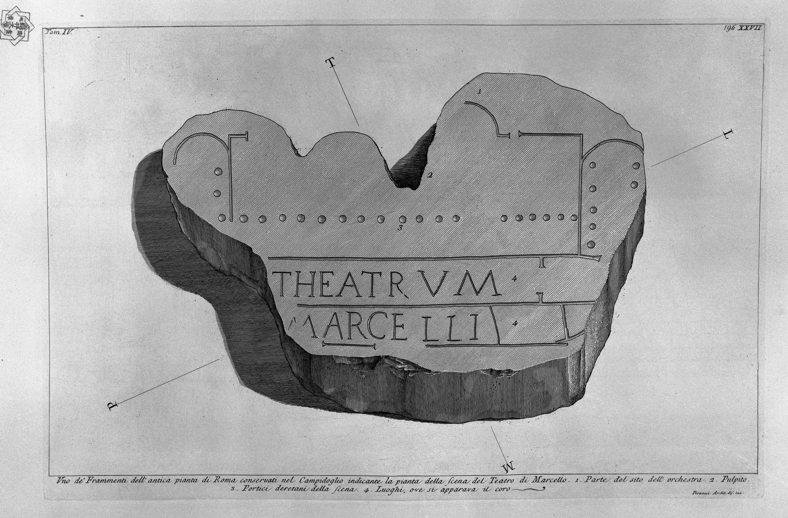
“The Forma Urbis Romae or Forma Urbis Severiana was a very large map of the imperial city of Rome (18 m long by 13 m high) carved on 151 marble slabs arranged in 11 rows, made under the reign of Emperor Septimius Severus, (between 203 and 211 CE). The 235 sqm map hung on a wall of an aula of the Templum Pacis (Forum della Pace). The same wall was later transformed into an exterior wall of the church of SS. Cosmas and Damian.
The Forma Urbis is one of the most extraordinary documents from imperial Rome and is a major source for the history of the city. The quality of the plan also documents Romans’ ability in realizing accurate topographical analysis and land surveys, in producing a perfectly orthogonal projection as well as their extremely developed skills in architectural and cartographic representation.”
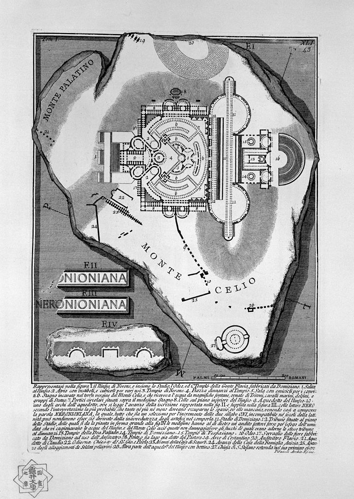
“Oriented with the Southeast at the top and based on a scale ranging between 1:240 to 1:250, the plan describes almost the whole city located inside the pomérium, the sacred enclosure of Rome. It is a ground plan, not an aerial view, where buildings are almost all horizontally sectioned at the level of the ground floor with walls delineated through a single line and columns by a single point, except for some specific monuments which are represented by double lines. The plan represents all the architectural elements of Rome, the insulae (residential areas), the monuments, the horrea (warehouses), and the temples, showing a scientific attitude in the description of the built environment.
Natural elements are omitted, (the river Tiber, for example, appears only by the absence of constructions). Several conventions are employed to symbolize stairs, represented through a “V”. However, since a legend is lacking, different hypotheses were formulated about the exact meaning of the different symbols appearing on the map.
The function of the plan is still ignored, but many scholars believe that the map had a utilitarian purpose, such as recording land ownership in Rome like a cadastral document. David West Reynolds, an American archaeologist, disagrees with this hypothesis as he states that the map would be impractical for utilitarian uses as it misses several features of other known roman cadastral maps, like annotations of land ownership and measurements. According to his point of view, the plan would have decorated the aula in which other maps on papyrus, much more detailed and easier to consult and handle, would have been used for cadastral purposes.
Thanks to the Forma Urbis, we acknowledged and were able to identify the location and form of some monuments which disappeared completely over time (like the Temple of the Divine Claude) and even of some which are never mentioned by other sources, like the Adonea.
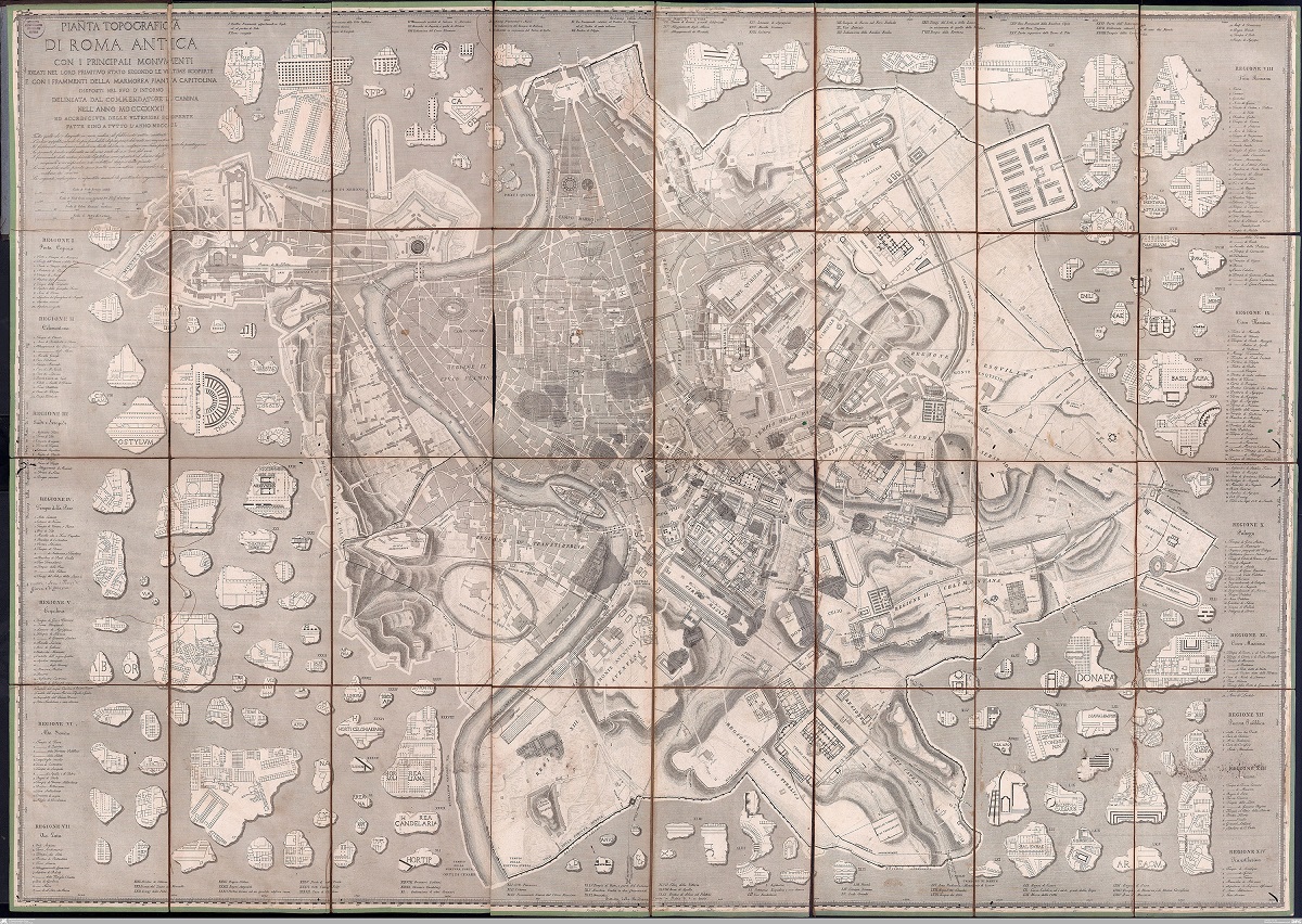
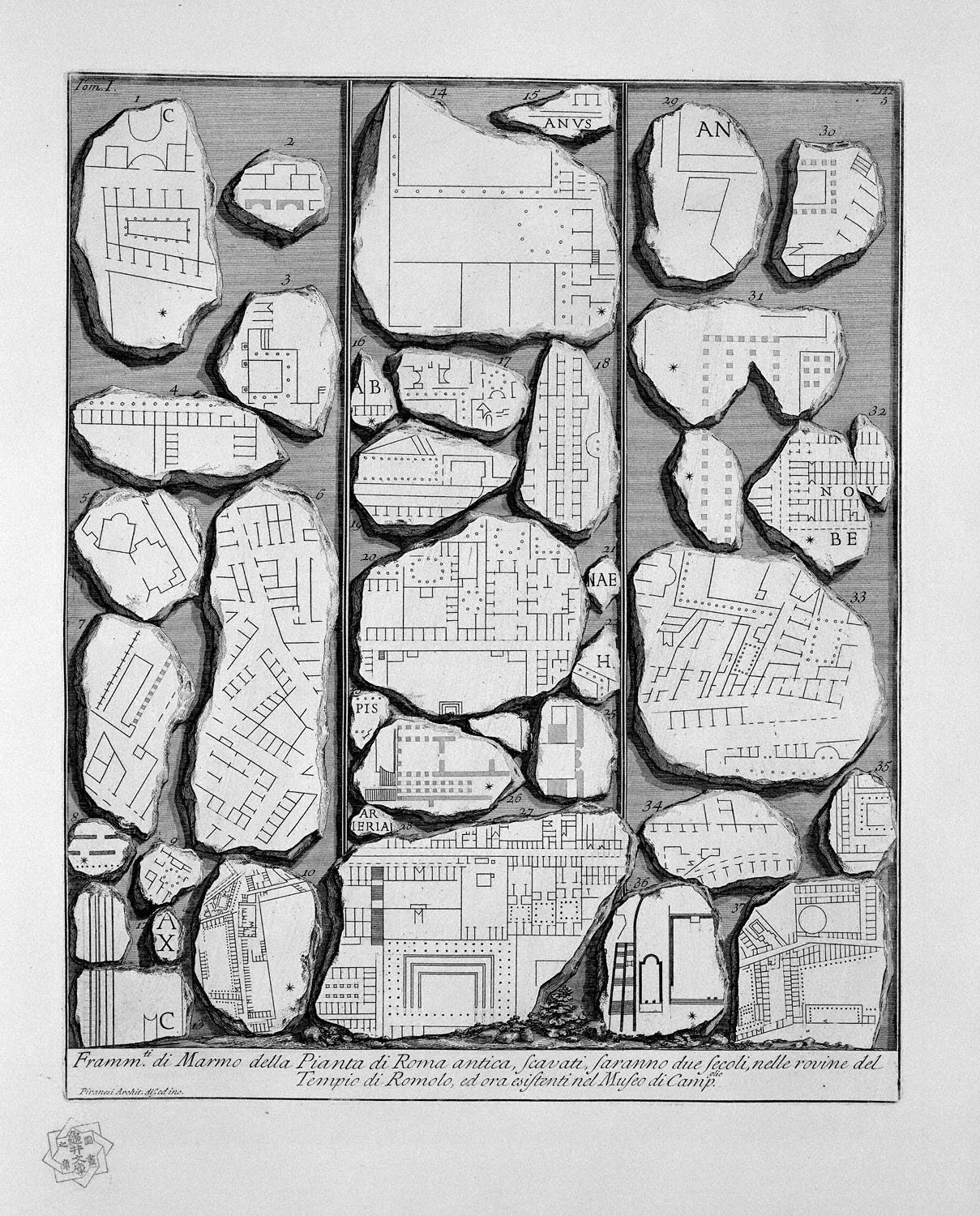
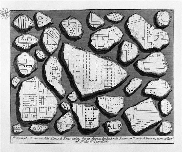
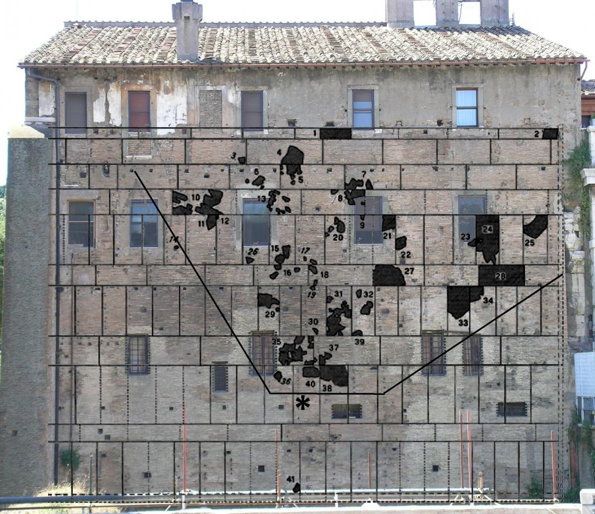
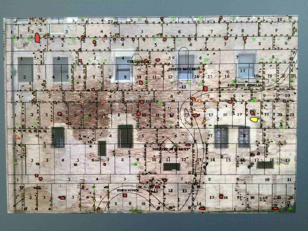
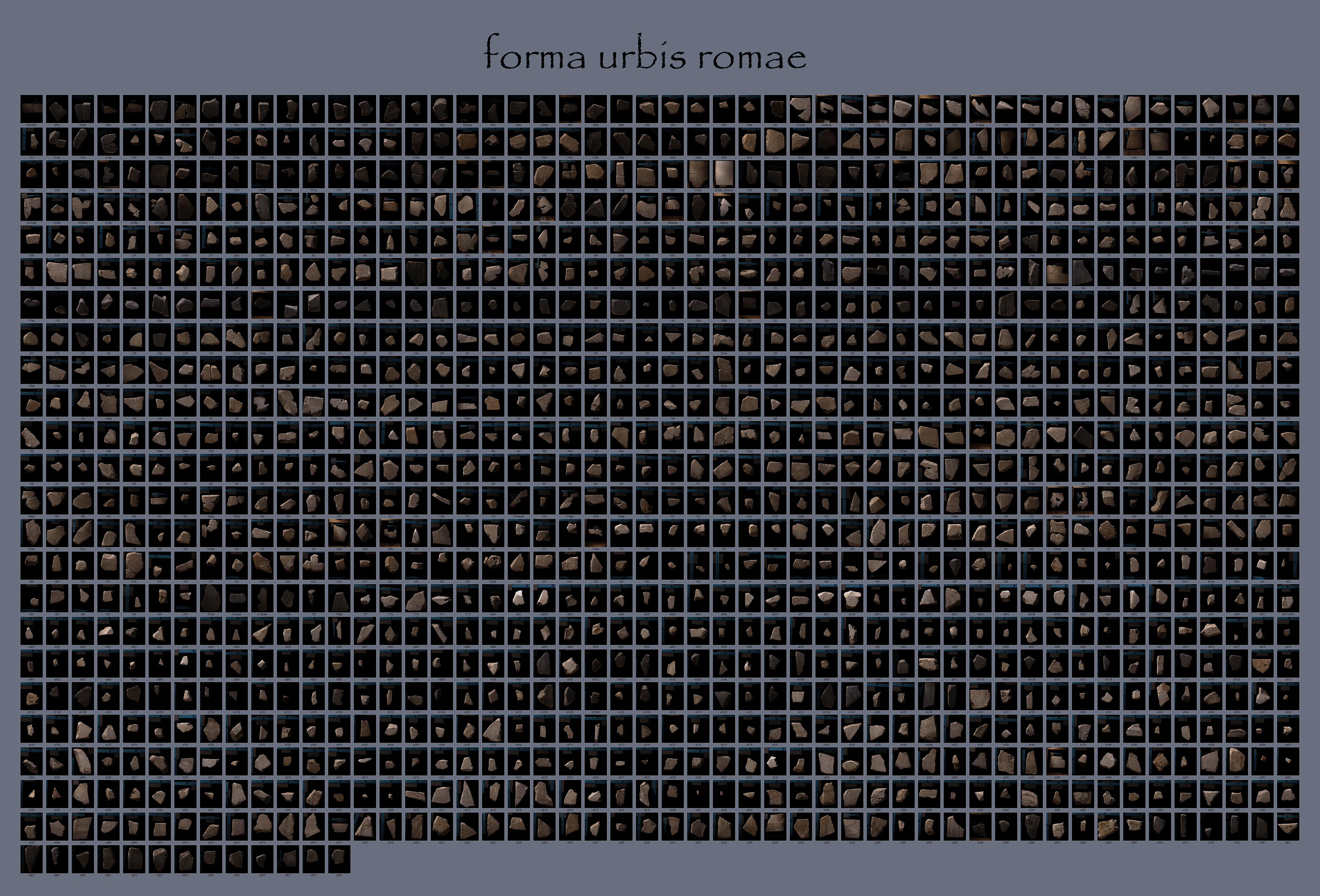
The Forma Urbis was gradually destroyed during the Middle Ages and used as building material for new constructions. Some of its fragments were rediscovered for the first time around 1562 when they have been dug from the site where the map originally stood. During the Seventeenth century, some scholars published and carefully documented the recovered fragments. Since then, further fragments were found during excavations in the area of the Imperial Fora of Rome and elsewhere in the city. Nowadays, about 11% of the original surface of the plan has been discovered in the form of 1,186 fragments, about half of which can be located on the surface. The plan has been studied and analyzed over centuries by numerous scholars who mostly focused on precise aspects: the reconstruction of the “puzzle”, the assembly of fragments, their positioning on the whole plan and the identification of the area represented.
In 1741-42 the fragments of the Marble Plan were moved to the Capitoline Museum where a major project of reassembling and exhibiting the fragments was undertaken by museum curator Pietro Forrier with the help of Giovanni Battista Nolli, soon to be the author of his own Pianta Grande di Roma together with the young Giovan Battista Piranesi assisting the research. The fragments were exhibited in wooden frames alongside the main staircase of the museum.”
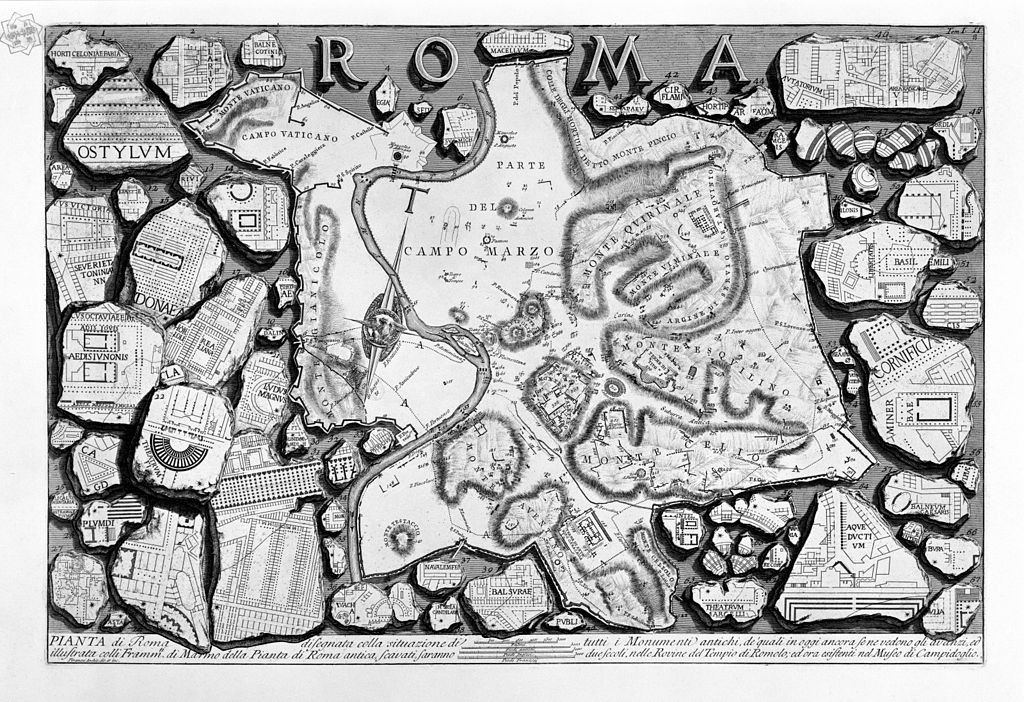
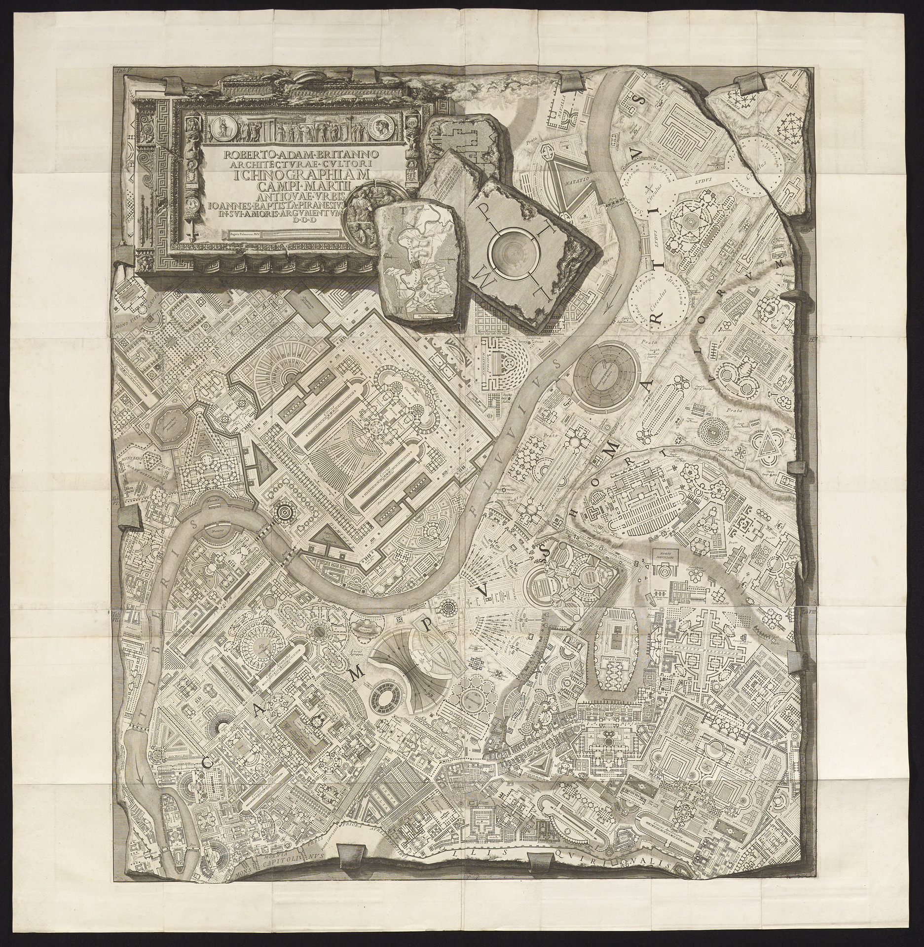
“The Forma Urbis Romae later became a recurring theme in Piranesi engravings. In plate II of the Antichità romane (1756), a plan of the city itself deprived of its architectural features is surrounded by one hundred and eighty two fragments of the marble plan rendered as three-dimensional objects. In the next two plates, the fragments are presented as arranged in wooden trays. Nearly twenty years after his work with Nolli, in 1762, Piranesi published his Ichnographiam Campi Martii antiquae urbis, part of the Campus Martius volume, where the reinvented plan of the imperial city is rendered as if it was carved on a marble slab.
The Forma Urbis was later profoundly studied by Italian archaeologist Rodolfo Lanciani who in 1901 published his own Forma Urbis Romae, a cartographic masterpiece overlapping layers of ancient Roman topography related to different time periods.
In 1960, after 30 years of careful research, the team directed by G.Carettoni produced one of the fundamental references on the Marble Plan: the monumental 2-volume edition La Pianta Marmorea di Roma Antica (Rome). This work presented photographic documentation of each known fragment and the most scientific review to date of the objects, along with a detailed bibliography, history, date, function, setting, and technique of the Plan, a list of Renaissance reproductions and various interpretations of all incised fragments. More information at this link.
Since the 1990s, computer scientists and archaeologists at the University of Stanford are working in collaboration with the Soprintendenza of the Comune di Roma on the “Forma Urbis Romae Project”, employing digital technologies to try and reconstruct the map through computer-aided reconstruction algorithms able to place each fragment at the right place. The scholars and technicians created digital photography and 3D models of each of the current 1,186 fragments and made all of them accessible online. For each fragment, there is an entry in a database providing all known information, the description, the identification, and the historical significance.”
“The Forma Urbis Romae or Forma Urbis Severiana was a very large map of the imperial city of Rome (18 m long by 13 m high) carved on 151 marble slabs arranged in 11 rows, made under the reign of Emperor Septimius Severus, (between 203 and 211 CE). The 235 sqm map hung on a wall of an aula of the Templum Pacis (Forum della Pace). The same wall was later transformed into an exterior wall of the church of SS. Cosmas and Damian.
The Forma Urbis is one of the most extraordinary documents from imperial Rome and is a major source for the history of the city. The quality of the plan also documents Romans’ ability in realizing accurate topographical analysis and land surveys, in producing a perfectly orthogonal projection as well as their extremely developed skills in architectural and cartographic representation.”
“Oriented with the Southeast at the top and based on a scale ranging between 1:240 to 1:250, the plan describes almost the whole city located inside the pomérium, the sacred enclosure of Rome. It is a ground plan, not an aerial view, where buildings are almost all horizontally sectioned at the level of the ground floor with walls delineated through a single line and columns by a single point, except for some specific monuments which are represented by double lines. The plan represents all the architectural elements of Rome, the insulae (residential areas), the monuments, the horrea (warehouses), and the temples, showing a scientific attitude in the description of the built environment.
Natural elements are omitted, (the river Tiber, for example, appears only by the absence of constructions). Several conventions are employed to symbolize stairs, represented through a “V”. However, since a legend is lacking, different hypotheses were formulated about the exact meaning of the different symbols appearing on the map.
The function of the plan is still ignored, but many scholars believe that the map had a utilitarian purpose, such as recording land ownership in Rome like a cadastral document. David West Reynolds, an American archaeologist, disagrees with this hypothesis as he states that the map would be impractical for utilitarian uses as it misses several features of other known roman cadastral maps, like annotations of land ownership and measurements. According to his point of view, the plan would have decorated the aula in which other maps on papyrus, much more detailed and easier to consult and handle, would have been used for cadastral purposes.
Thanks to the Forma Urbis, we acknowledged and were able to identify the location and form of some monuments which disappeared completely over time (like the Temple of the Divine Claude) and even of some which are never mentioned by other sources, like the Adonea.
The Forma Urbis was gradually destroyed during the Middle Ages and used as building material for new constructions. Some of its fragments were rediscovered for the first time around 1562 when they have been dug from the site where the map originally stood. During the Seventeenth century, some scholars published and carefully documented the recovered fragments. Since then, further fragments were found during excavations in the area of the Imperial Fora of Rome and elsewhere in the city. Nowadays, about 11% of the original surface of the plan has been discovered in the form of 1,186 fragments, about half of which can be located on the surface. The plan has been studied and analyzed over centuries by numerous scholars who mostly focused on precise aspects: the reconstruction of the “puzzle”, the assembly of fragments, their positioning on the whole plan and the identification of the area represented.
In 1741-42 the fragments of the Marble Plan were moved to the Capitoline Museum where a major project of reassembling and exhibiting the fragments was undertaken by museum curator Pietro Forrier with the help of Giovanni Battista Nolli, soon to be the author of his own Pianta Grande di Roma together with the young Giovan Battista Piranesi assisting the research. The fragments were exhibited in wooden frames alongside the main staircase of the museum.”
“The Forma Urbis Romae later became a recurring theme in Piranesi engravings. In plate II of the Antichità romane (1756), a plan of the city itself deprived of its architectural features is surrounded by one hundred and eighty two fragments of the marble plan rendered as three-dimensional objects. In the next two plates, the fragments are presented as arranged in wooden trays. Nearly twenty years after his work with Nolli, in 1762, Piranesi published his Ichnographiam Campi Martii antiquae urbis, part of the Campus Martius volume, where the reinvented plan of the imperial city is rendered as if it was carved on a marble slab.
The Forma Urbis was later profoundly studied by Italian archaeologist Rodolfo Lanciani who in 1901 published his own Forma Urbis Romae, a cartographic masterpiece overlapping layers of ancient Roman topography related to different time periods.
In 1960, after 30 years of careful research, the team directed by G.Carettoni produced one of the fundamental references on the Marble Plan: the monumental 2-volume edition La Pianta Marmorea di Roma Antica (Rome). This work presented photographic documentation of each known fragment and the most scientific review to date of the objects, along with a detailed bibliography, history, date, function, setting, and technique of the Plan, a list of Renaissance reproductions and various interpretations of all incised fragments. More information at this link.
Since the 1990s, computer scientists and archaeologists at the University of Stanford are working in collaboration with the Soprintendenza of the Comune di Roma on the “Forma Urbis Romae Project”, employing digital technologies to try and reconstruct the map through computer-aided reconstruction algorithms able to place each fragment at the right place. The scholars and technicians created digital photography and 3D models of each of the current 1,186 fragments and made all of them accessible online. For each fragment, there is an entry in a database providing all known information, the description, the identification, and the historical significance.”